Showing 120 items matching black river group
-
 Marysville & District Historical Society
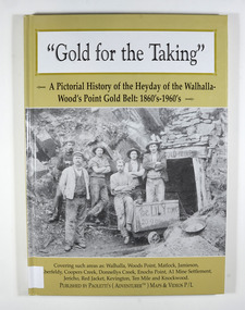
Book - Hardcover book, Gold for the Taking-A Pictorial History of the Heyday of the Walhalla-Wood's Point Gold Belt: 1860's-1960's, 2007
... black river group... settlement aberfeldy beardmore black river group coopers creek ...A pictorial history of the heyday of the Walhalla-Wood's Point gold belt in the 1860's-1960'sHardcover. The cover is a gold colour. The front cover has a photograph of a group of miners in front of the entry to a mine. On the top entry timber piece is a sign saying "Old Mine". The beginning of the wording is obscured by one of the miners standing in front of the entry. There is also an old mining trolley standing on tracks which lead into the mine.There is also an old gold mining dish sitting on a rock to the left of the entry into the mine.On the back cover is a photograph of Walhalla in modern times as well as a photograph of the publisher of this book. There is also a blurb about the publisher.Stamp of the Marysville & District Historical Society Inc / P.O. Box 22 / Marysville 3779gold, gold fields, gold mining, a1 mine settlement, aberfeldy, beardmore, black river group, coopers creek, donnellys creek, enochs point, fulton creek, gaffneys creek, gooleys creek, jamieson, jordan valley, kevington, knockwood, matlock, ten mile, walhalla, wood's point, history, victoria -
 Greensborough Historical Society
Photograph (copy), Happy Hollow, 13/4/1994
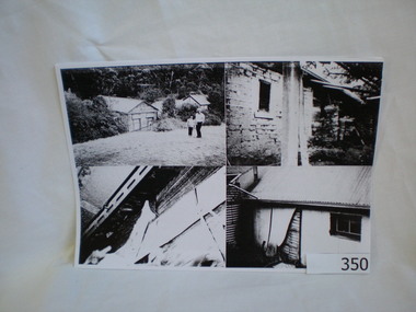
A group of 4 photographs taken in 1994 and an early photograph of the same building for comparison.Happy Hollow farm was located on the Plenty River about 4 km upstream for the Greensborough township. It was originally built in the late 1840's and was rented by the Whatmough family at one time. It is now lost as it was taken over by Parks Victoria, left derelict and burnt down by vandals in the early 2000's.A group of photocopied photographs on A4 size paper. There is a black and wihte copy as well as a colour copy of 4 photographs with transcriptions on the rear of the sheet. The other sheet shows the building in the mid 1800's.Details on the reverse of 2 sheets about the photographs on the obverse.happy hollow farm, bell family, plenty river, whatmough -
 Greensborough Historical Society
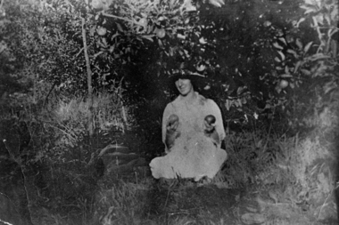
Photograph - Digital Image, Mrs Greenwood with two apples; and, older Gladys Greenwood: group of photographs, 1927c
A young Mrs Greenwood is seen posing with two apples; an older Miss Gladys Greenwood (daughter of Mrs Greenwood) is seen at a celebration. The Greenwood family share farmed with the Bosch family.The area of Greensborough along the Plenty River was known for its orchards, which might explain why Mrs Greenwood is photographed holding the apples.Digital copy of one black and white photograph and one colour photograph.greenwood, gladys greenwood -
 Greensborough Historical Society
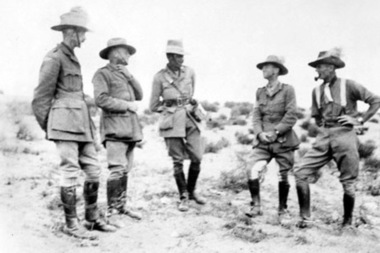
Photograph - Digital image, Leslie Cecil Maygar and group of soldiers, 1900c
The Maygar family came to Greensborough circa 1841 from Somerset England. They were of Hungarian descent. They farmed along the Plenty River. Leslie Cecil Maygar VC, DSO, VD was an Australian recipient of the Victoria Cross. In 1901 Lieutenant Maygar was awarded the Victoria Cross for rescuing a fellow Victorian whose horse had been shot. He died at Beersheeba in Palestine in 1917.Digital copy of black and white photograph.leslie cecil maygar, maygar family -
 Greensborough Historical Society
Photograph - Digital image, Untitled 1937, 1937_
Photograph of a group of people on the banks of the river. Part of a collection of photographs owned by Dorris McLaughlin who was born in Greensborough, in 1899 to John McLaughlin and Rosalie Ellen Whatmough. The collection contains photographs of friends and relatives from the Greensborough and Eltham areas.Digital copy of black and white photograph.dorris mclaughlin -
 Greensborough Historical Society
Photograph - Digital image, Outing at Laughing Waters on The Yarra River, 1935, 1935_
Part of a collection of photographs owned by Dorris McLaughlin who was born in Greensborough, in 1899 to John McLaughlin and Rosalie Ellen Whatmough. The collection contains photographs of friends and relatives from the Greensborough and Eltham areas. This photograph shows a large group of people sitting beside the river.Digital copy of black and white photograph.dorris mclaughlin, laughing water -
 Greensborough Historical Society
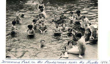
Photograph - Digital image, Swimming pool, Plenty River 1952, 1952_
A group of children enjoy a swim in the Plenty River pool Greensborough in 1952. Opened in 1937, the remnants of this pool can be seen today. (Gary Partington is the boy in the centre).The remnants of this concrete pool can still be seen today.Digital copy of black and white photograph.greensborough swimming pool, plenty river swimming pool -
 Federation University Historical Collection
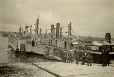
Photograph - Black and White, St. Hilda's Bus and band members boarding the Torpoint Ferry, on the River Tamar, 1934
Frank Wright was a renown resident of Smeaton, where he was born on 2 August 1901. He lived at Laura Villa, and attended Smeaton State School. His father William was a gold miner and his mother's name was Sarah. Their family won many singing and instrumental awards. Frank was tutored by Percy Code and was awarded a gold medal for the highest marks in the ALCM examinations in the British Colonies at the age of seventeen years. He became the Australian Open Cornet Champion by the age of eighteen. A year later, Frank conducted the City of Ballarat Band, and later the Ballarat Soldiers’ Memorial Band. He formed the Frank Wright Frisco Band and Frank Wright and his Coliseum Orchestra. These bands won many South Street awards, and Frank as conductor won many awards in the Australian Band Championship contest. In 1933 Frank Wright sailed to England to conduct the famous St Hilda’s Band and was later appointed Musical Director of the London County Council, where he organized many amazing concerts in parks, in and around the London district. He was made Professor of Brass and Military Band Scoring and conducted at the Guildhall of Music and Drama. Frank was often invited to adjudicate Brass Band Championships around Europe, in Australia, including South Street and in New Zealand. The Frank Wright Medal at the Royal South Street competition is awarded to an individual recognized as making an outstanding contribution to brass music in Australia.Black and white photograph of an early 1930's bus boarding a vehicle and passenger chain ferry. A group on men dressed in a band uniform are standing and watching the bus's progress. Land can be seen on both sides of the Tamar River. It is the Torpoint Ferry between Devonport in Plymouth and Torpoint in Cornwall. The men are the St. Hilda's Band, including Frank Wright, the conductor.Written in pencil on back - St Hilda's Bus on Torpoint Ferry between Devon and Cornwall, 1934frank wright, st hilda's band, st hilda's bus, brass band, torpoint ferry -
 Federation University Historical Collection
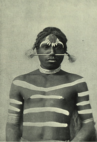
Image - black and white, Barwon River Man (New South Wales)
Digitised directly from 'The Native Races of the British Empire: Victoria' The Barwon River in New South Wales is formed through the confluence of the Macintyre River and Weir River (part of the Border Rivers system), north of Mungindi, in the Southern Downs region of Queensland. The Barwon River generally flows south and west, joined by 36 tributaries, including major inflows from the Boomi, Moonie, Gwydir, Mehi, Namoi, Macquarie, Bokhara and Bogan rivers. During major flooding, overflow from the Narran Lakes and the Narran River also flows into the Barwon. The confluence of the Barwon and Culgoa rivers, between Brewarrina and Bourke, marks the start of the Darling River.Black and white Image of an Aboriginal man from Barwon River, New South Wales. Aboriginal people from six language groups originally occupied the area of the Barwon River wetlands. These were the Ngemba, the Baranbinja, the Murrawari, the Ualayai, the Weilwan, and the Kamilaroi peoples. The Aboriginal people generally used the wetlands for hunting, fishing, and gathering uses, and for cultural association.(Wikipedia) The name "barwon" is derived from the Australian Aboriginal words of barwum or bawon, meaning great, wide, awful river of muddy water; and also baawan, a Ngiyambaa name for both the Barwon and Darling rivers. The history, culture and livelihoods of the local Aboriginal people are closely intertwined with the Barwon River and its associated tributaries and downstream flows. (Wikipedia)aborigine, aboriginal, barwon river -
 Federation University Historical Collection
Map - Geological, Tallangatta, New South Wales: 1:250,000 Geological Series, SJ 55-3, 1966
Compiled by the Geological Survey of N.S.W., Division of Regional Geology. Topographical base compiled from Snowy Mountains Hydro Electrical Authority, Department of Lands, County maps and Snowy Lease Map. Other sheet adjoin this map. There are 13 formation sections grouped into 9 - Quaternary, Tertiary, Middle Devonian, Lower to Middle Devonian, Lower Devonian, Upper Silurian, Silurian, Upper Ordovician and Ordovician.Large coloured map showing geological features, faults, bores, rivers and mineral deposits.Scale of map, longitude and latitude, river names. "Tallangatta 1:250,00" written in black pen.tallangatta, new south wales, geological survey, topographical base, snowy mountains hydro electrical authority, department of lands, snowy lease map, department of mines, quaternary, tertiary, middle devonian, lower to middle devonian, lower devonian, uper siluran, silurian, upper ordovician, ordovician -
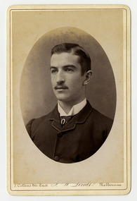 Marysville & District Historical Society
Photograph (Item) - Black and white portrait, John William Lindt, 1870s
A black and white portrait of an unknown man taken by John William Lindt.A black and white portrait of an unknown man taken by John William Lindt. John William Lindt was born in Germany in 1845. At 17 he took a working passage to Australia on a Dutch sailing ship. Taking up work as an itinerant piano-tuner, he traveled amongst towns in Victoria and New South Wales before settling in Grafton in 1863 where he became assistant and apprentice to photographer Conrad Wagner. After a brief return to Germany in 1867 Lindt took over management of Wagner’s studio in 1869. He married Wagner’s daughter, Anna on 13 January 1872. Over 1873-1874, using the slow and laborious wet-plate collodion process, John Lindt produced photographs of the local indigenous people both in their environment conducting actual traditional ceremonies in the Clarence River district, and in his studio. Twelve of this series is included in his 1874 album Australian Aboriginals. John Lindt moved to Melbourne in 1876 where he worked for Batchelder & Co. before opening his own opulent studios at number 7 at the top of Collins Street opposite the Treasury, in 1877. John Lindt's business of this period was wide-ranging, and included portraits, records of Melbourne public buildings and streetscapes, the Botanical Gardens, and Port Melbourne. He was a welcome photographer of members of parliament and other Melbourne personalities, their society and cultural life including the theatre, and was known as a ‘rich man’s photographer’ for those whose families he grouped informally on the lawns in front of their mansions, with servants at the rails of the upstairs balconies. He continued with landscape, producing folios Fernshaw and Watt River Scenery, Victoria ( c.1878-82), Scenery on the Ovens and Buckland Rivers, Victoria (c.1878–82) and Lorne, Louttit Bay and Cape Otway Ranges (1883). Sales of his Black Spur scenery amounted to approximately 25,000 copies printed from the original negatives between 1882 and 1892. John Lindt, in collaboration with Nicholas John Caire, produced a tourist booklet on the area around "The Hermitage" in 1913.7 Collins Str. East/ J.W. Lindt/ Melbournejohn william lindt, conrad wagner, australian aboriginals, batchelder & co, nicholas john caire, anna lindt -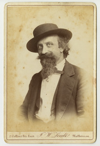
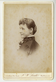 Marysville & District Historical Society
Photograph (Item) - Black and white portrait, John William Lindt, 1870s
A black and white portrait of an unknown woman taken by John William Lindt.A black and white portrait of an unknown woman taken by John William Lindt. John William Lindt was born in Germany in 1845. At 17 he took a working passage to Australia on a Dutch sailing ship. Taking up work as an itinerant piano-tuner, he traveled amongst towns in Victoria and New South Wales before settling in Grafton in 1863 where he became assistant and apprentice to photographer Conrad Wagner. After a brief return to Germany in 1867 Lindt took over management of Wagner’s studio in 1869. He married Wagner’s daughter, Anna on 13 January 1872. Over 1873-1874, using the slow and laborious wet-plate collodion process, John Lindt produced photographs of the local indigenous people both in their environment conducting actual traditional ceremonies in the Clarence River district, and in his studio. Twelve of this series is included in his 1874 album Australian Aboriginals. John Lindt moved to Melbourne in 1876 where he worked for Batchelder & Co. before opening his own opulent studios at number 7 at the top of Collins Street opposite the Treasury, in 1877. John Lindt's business of this period was wide-ranging, and included portraits, records of Melbourne public buildings and streetscapes, the Botanical Gardens, and Port Melbourne. He was a welcome photographer of members of parliament and other Melbourne personalities, their society and cultural life including the theatre, and was known as a ‘rich man’s photographer’ for those whose families he grouped informally on the lawns in front of their mansions, with servants at the rails of the upstairs balconies. He continued with landscape, producing folios Fernshaw and Watt River Scenery, Victoria ( c.1878-82), Scenery on the Ovens and Buckland Rivers, Victoria (c.1878–82) and Lorne, Louttit Bay and Cape Otway Ranges (1883). Sales of his Black Spur scenery amounted to approximately 25,000 copies printed from the original negatives between 1882 and 1892. John Lindt, in collaboration with Nicholas John Caire, produced a tourist booklet on the area around "The Hermitage" in 1913.7 Collins Str. East/ J.W. Lindt/ Melbournejohn william lindt, conrad wagner, australian aboriginals, batchelder & co, nicholas john caire, anna lindt -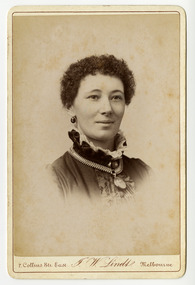
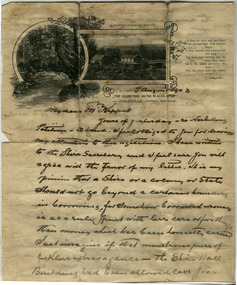 Marysville & District Historical Society
Letter (Item) - Hand written letter, John William Lindt, 1903
A letter written to Maurice Keppel by John William Lindt in 1903.A letter written to Maurice Keppel by John William Lindt in 1903. John William Lindt was born in Germany in 1845. At 17 he took a working passage to Australia on a Dutch sailing ship. Taking up work as an itinerant piano-tuner, he traveled amongst towns in Victoria and New South Wales before settling in Grafton in 1863 where he became assistant and apprentice to photographer Conrad Wagner. After a brief return to Germany in 1867 Lindt took over management of Wagner’s studio in 1869. He married Wagner’s daughter, Anna on 13 January 1872. Over 1873-1874, using the slow and laborious wet-plate collodion process, John Lindt produced photographs of the local indigenous people both in their environment conducting actual traditional ceremonies in the Clarence River district, and in his studio. Twelve of this series is included in his 1874 album Australian Aboriginals. John Lindt moved to Melbourne in 1876 where he worked for Batchelder & Co. before opening his own opulent studios at number 7 at the top of Collins Street opposite the Treasury, in 1877. John Lindt's business of this period was wide-ranging, and included portraits, records of Melbourne public buildings and streetscapes, the Botanical Gardens, and Port Melbourne. He was a welcome photographer of members of parliament and other Melbourne personalities, their society and cultural life including the theatre, and was known as a ‘rich man’s photographer’ for those whose families he grouped informally on the lawns in front of their mansions, with servants at the rails of the upstairs balconies. He continued with landscape, producing folios Fernshaw and Watt River Scenery, Victoria ( c.1878-82), Scenery on the Ovens and Buckland Rivers, Victoria (c.1878–82) and Lorne, Louttit Bay and Cape Otway Ranges (1883). Sales of his Black Spur scenery amounted to approximately 25,000 copies printed from the original negatives between 1882 and 1892. John Lindt, in collaboration with Nicholas John Caire, produced a tourist booklet on the area around "The Hermitage" in 1913. Maurice Keppel, from Ireland, was one of the first landholders in the newly surveyed town of Marysville in 1864. He and his wife ran the successful Keppel’s Australian Hotel. Two of their sons, John and Jerry, established a farm and opened up the surrounding high country. The Keppel lease was one of the longest held in the high country and the Keppel Family were amongst Marysville's pioneering families.maurice keppel, keppel family, keppel's australian hotel, marysville, victoria, john william lindt, conrad wagner, australian aboriginals, batchelder & co, nicholas john caire, anna lindt -
 Kiewa Valley Historical Society
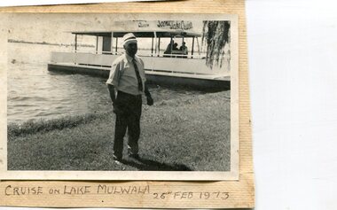
Photographs x 3- Cruise on Lake Mulwala, 25/2/1973
Lake Mulwala is a man–made reservoir created through the construction of the Yarrawonga Weir across the Murray River, is located between Bundalong and Yarrawonga in Hume region of Victoria and Mulwala in the Riverina region of New South Wales, in eastern Australia. The weir was constructed in 1939 to provide water for irrigation of the surrounding district. The weir also serves as a crossing of the Murray between the two towns. It is a popular tourist destination for boating, fishing and other water recreation.Photographs demonstrate local Kiewa Valley residents enjoying a visit to the picturesque area of Lake Mulwala. Also provides a pictorial history of 1973.3 black and white photographs mounted on buff card. Photographs of a cruise on Lake Mulwala 25th Feb. 1973 1. Photo of unidentified man standing on the shore of Lake Mulwala beside cruise launch. 2. Group photo of people standing by cruise boat as others disembark. Woman in centre holding handbag may be Clare Roper (unconfirmed) 3. Photo of 2 men aboard cruise launch looking out over Lake Mulwala1. Handwritten at bottom of photo in black ink. 'Cruise on Lake Mulwala. 25th Feb. 1973' 2. Painted sign above cruise launch- Scenic Lake Cruises 3. No markingsclare roper -
 Kiewa Valley Historical Society
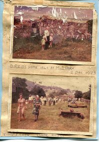
Photographs x 2- D Reids home at Mill Park 1973, 2/12/1973
David Reid (1820-1906) was a pastoralists and politician. He left school at 16 and after meeting the overlander John Gardiner he decided to look for land south of the Murray River. Equipped by his father with some 500 head of cattle, 2 bullock wagons and teams and 6 assigned servants, he reached the Ovens River on 8 September 1838. David settled at Currargarmonge, near Wangaratta. At the end of 1843 he took up land near Yackandandah. In 1847 he took up a section of the family run of which Woorajay (Wooragee) formed a part. He built the first water driven flour-mill in the district on his Yackandandah run in 1845; his woolclip of 1848 was one of the first to be handled by R. Goldsbrough and was claimed to come from sheep descended from stock imported in the 1820s from George III's flock. Going into politics, he held the Legislative Assembly seat of Murray from October 1859 to May 1862. David Reid was a highly regarded grazier and local politician who was significantly involved in settlement around the Yackandandah area. Photo demonstrates ongoing interest in the local history of the area and its early residents2 colour photographs mounted together on buff card 1. Man and 2 children (unidentified) standing outside the remains of the Reid home. 2 Dec, 1973 2. Group of unidentified people on a tour of the old homestead of D. Reid. 2 Dec, 19731. Handwritten in black ink under photo 'D. Reid's home 1845. At Mill Park. 2 Dec 1973 2. Handwritten in blue ink under photo 'Snapshots Clare Roper"clare roper -
 Orbost & District Historical Society
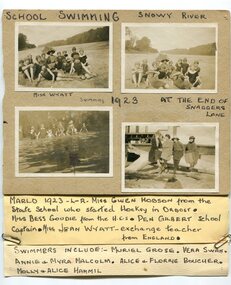
black and white photographs, 1923
These are photographs of students at the Orbost Higher Elementary School in 1923. They were taken at the Snaggers Lane end of the Snowy River. with the students is teacher, Miss Wyatt. In the photograph, bottom right, from L-R are Miss Gwen Hobson from the Orbost state School who started hockey in Orbost; Miss Bessie Goudie from the Higher Elementary School, Pen Gilbert, school captain, Miss Jean Wyatt an exchange teacher from England. the swimmers include Muriel Grose; Vera Swan; Annie and Myra Malcolm, Alice and Florrie Boucher and Mollie and Alice Hammil. During 1910-11 the first approaches were made to the Department for the establishment of a HES in Orbost and this became a reality in 1912. Orbost HES supplied post-primary education in the district until a high school was built in 1948.Orbost High School / Orbost Secondary College has played a significant part in the education of senior students in the Orbost district . It is the sole senior educational institution. This item is representative of its history. Four black / white photographs pasted onto grey cardboard. each is labelled - had-written in black print. A label is attached to the bottom of the card. Two of the photographs are of groups of students wearing swimming costumes sitting on a river bank A teacher is with them holding an open umbrella. Another photograph is of a group of students in swimming costumed standing in water. The other is of four women sitting on a large tree log in front of a wooden building.at top - "SCHOOL SWIMMING SNOWY RIVER" There are hand-written labels under the photographs and a list of names attached to the bottom with metal paper clips.education-orbost orbost-higher-elementary-school swimming-carnival -
 Orbost & District Historical Society
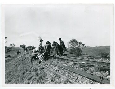
black and white photograph, mid - second half 20th century
This photograph was taken near the Nicholson River Bridge. The gang re-laying the rail tracks on the Bairnsdale - Orbost line were working in the Bruthen area. In this photograph the men had just finished work near the Nicholson River Bridge.This photograph is associated with the Easy Gippsland Railway.A black / white photograph of a group of men working on a railway line. There is another group behind them.on back - typed information as beloweast-gippsland-railway nicholson-railway railway-construction -
 Orbost & District Historical Society
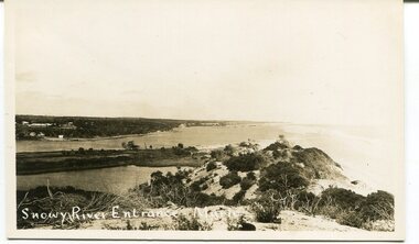
black and white photograph, C 1890s -1910
This is a photograph of the entrance of the Snowy River to Bass Strait. The entrance changes location but remains open for most of the year, although on occasions is closed by the prevailing weather and river water levels. In this photograph the entrance is quite wide and near the Marlo Hotel. This is a pictorial record of the Snowy River entrance at Marlo showing an open entrance.A black / white photograph / postcard of sandhills, river water on left and ocean on right. There is a group of buildings in the background - left. on front - "Snowy River Entrance Marlo"snowy-river-entrance marlo-snowy-river -
 Orbost & District Historical Society
black and white photograph, 1920s - 1930s
There is no record of which family is in the photograph. The slips at Corringle was a popular picnic area for Orbost people. Corringle Slips is situated at the mouth of the Snowy River Estuary. The Corringle Slips were built by Samuel Richardson and sons during the time when the Orbost Shipping Company was operating. The Slips were washed away in the 1893 floods and reassembled by Martin Jorgensen who then became a part owner of the Slips. In the late 1890's, Corringle was a thriving rural community. (Information from Discovering Marlo brochure)This is a pictorial record of family life in Orbost in the first half of the 20th century. It portrays a typical Orbost family enjoying a leisure activity. The clothing can be seen as more formal than that worn at a family picnic in the present day,A black / white photograph of a group of people (adults and children) seated around a table set with a tablecloth on which are teacups, bottles of drink and cake. in the front is a bucket and two metal boxes. They are well-dressed with the men and boys wearing jackets and ties and some of the women wearing cloche style hats.on back - "Family at Slips"corringle-slips-marlo picnic-recreation -
 Orbost & District Historical Society
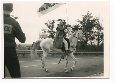
black and white photographs, November 1976
All of these photographs were taken prior to 25th November, 1876, the official opening and crossing of the current Snowy River Bridge. Gary Downey, an Orbost Apeian, did a "De Groot" and crossed the bridge on horseback prior to the official cars crossing the bridge to signal the opening of the new structure. There was a closing ceremony for the old bridge with a group arriving in a 1927 Chrysler, owned by Apexian, Peter Dreverman. This was watched by groups of school students. Some of the Apex members, including Jim Duggan, Noel Smart and Pat Hall, dressed in formal attire to speak to the audience.This event was organised by the Apex Club of Orbost.The Apex Club of Orbost was a volunteer service club which contributed to the Orbost community. A declining population has led to the demise of many social groups in the area.Ten black / white photographs related to the unofficial opening of the Snowy River Bridge at Orbost. snowy-river-bridge-1976 apex-club-orbost ceremony -
 Orbost & District Historical Society
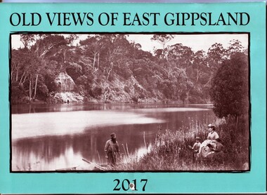
calendar, E-Gee Printers, Old Views of East Gippsland 2017, 2016
This is one of a series of calendars compiled annually by East Gippsland Historical Society.This is a useful pictorial reference tool.A 2017 stapled calendar, titled "Old Views of East Gippsland". On the turquoise coloured front is a black/white photograph of Eagle Point, Mitchell River C 1875 with a family group, possibly Alfred Howitt and children, on the bank of the Mitchell River opposite Eagle Point Bluff.. It contains early photographs of East Gippsland,. There is a hole for hanging. The title is at the top and the year at the bottom in black print. calendar-old-views-of-east-gippsland photographs-historic-east-gippsland -
 Orbost & District Historical Society
black and white photograph, late 19th - early 20th century
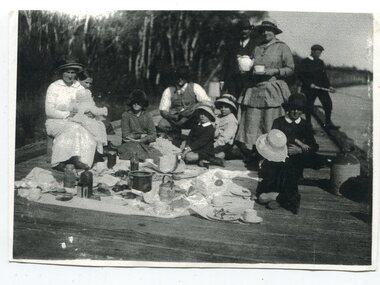
this is a photograph taken at the original jetty at Tabbara on the Brodribb River used by Samuel Richardson who established his mill in 1882. There was a constant demand for timber to supply the growing townships of Orbost , Marlo and surrounds. It was at this mill that the original paddle steamer Curlip was built. More information in "Curlip" by May Leatch. Helena Warrem (1871-1962) was a self-taught photographer who became both the local press correspondent and a producer of humorous trompe l'oeil postcard images. Helena Warren was a thirty-two year old settler living on a small mixed farm with her husband, William, at Newmerella, near Orbost in Gippsland, Victoria, when she bought her first camera, an Austral Box quarter-plate. Her family says she was entirely self-taught, like many women photographers who started out with nothing but the instructions on the packets of film and chemicals. In over fifty years practice she graduated from the total novice, who opened all her first mail order plates in bright sunlight and ruined them, to a competent photographer who became both the local press correspondent and an inveterate producer of humorous trompe l’oeil postcard images. Helena Francis Warren (nee McKeown) was married to William John Warren and lived in Newmerella. She supplied the photos for the Back-To-Orbost celebration book in 1937 and also designed the Back-To-Orbost badge. She was known for her soft toy making. (by Ivy Rodwell in from Personalities and Stories of the Early Orbost District by Mary Gilbert).This photograph is a pictorial record of a typical family activity in the late 19th - early 20th century in the Orbost area, The clothing and manners are reflective of that time, This photograph also has significance in its association with Helen Frances Warren, a popular Orbost identity who was well known as an accomplished photographer and needleworker,A black / white photograph of a family group seated on a wooden jetty. There is a man on the right with a fishing rod. A man is standing next to woman holding a teapot and cup and saucer. On the left a woman is sitting and holding a baby on her knee. The rest are sitting or kneeling with a picnic cloth spread in front of them. There are bottles, jars, plates and cups on the cloth. on back - "The Warren Family Tabara Jetty"tabbara-jetty warren-family-orbost recreation-picnic -
 Orbost & District Historical Society
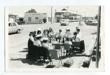
black and white photograph, 1. 12. 1973
This photograph was published in the Snowy River Mail on November 27 1974. "Shoppers in Nicholson Street, Orbost, have been treated to band music each Saturday morning when members of Orbost Municipal Band have rendered items in the shopping centre. Members, both senior and junior, are pictured here as they prepare instruments for a recital on a sunny Saturday." The photograph was taken by Peter Fagg in Nicholson Street on the corner of Wolseley Street on Saturday morning 1.12.1973. The first Orbost Brass Band was formed in 1889. Around 1908 the town band split and the Orbost Workers' Band was formed. Eventually the two bands merged in 1913 to reform as the Orbost Municipal Band under conductorship of Charles Spink. The band continued for many years but was later disbanded and again reformed. This was to happen a number of times, the last time being in 1961 and continuing through to the late 1970's. Further info and Ref: In Times Gone By - Deborah Hall This is a pictorial record of the Orbost Municipal Band. The various Orbost bands over the years played a major role in community activities providing entertainment and musical experiences for the many members.A black / white photograph of a group,of uniformed band members sitting in a circle at the edge of a main street. Each is holding a musical instrument with music stands in front of them.music-orbost orbost municipal band recreation entertainment -
 Orbost & District Historical Society
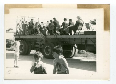
black and white photograph, October 4 1978
From the Snowy River Mail October 4 1978 page 9 - " A MOBILE BAND - Although Orbost Municipal Band participated in Saturday's Primary School workathon, members feet didn't touch the ground. They idi it bthe easywayon the trailer of a truck. The band encouraged walkers with stirring music along the road to Marlo." The first Orbost Brass Band was formed in 1889. Around 1908 the town band split and the Orbost Workers' Band was formed. Eventually the two bands merged in 1913 to reform as the Orbost Municipal Band under conductorship of Charles Spink. The band continued for many years but was later disbanded and again reformed. This was to happen a number of times, the last time being in 1961 and continuing through to the late 1970's. Further info and Ref: In Times Gone By - Deborah Hall This is a pictorial record of the Orbost Municipal Band. The various Orbost bands over the years played a major role in community activities providing entertainment and musical experiences for the many members.A black / white photograph showing a group of uniformed band members sitting on folding chair s on the tray of a large flat bed truck. They are holding musical instruments. A young boy is sitting on the edge of the tray and three other children are standing on the road nearby.on back - information from S.R.M.music orbost-municipal-band entertainment recreation -
 Orbost & District Historical Society
black and white photograph, November 1975
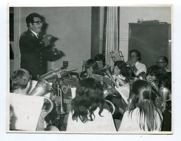
This photograph was taken inside St James Hall, Orbost at the 75th anniversary of the Orbost Municipal Band.on November 8, 1975. It was published in the Snowy River Mail on November 12, 1975 under the heading "ANNIVERSARY FOR BAND". "Some 250 people filled St James Hall on the occasion of the 75th anniversary of the band, The evening began with a buffet dinner followed by a recital by the members of the band, The fitting numbers chosen were favourites throughout the different eras during the band's 75 years. A display of old brass instruments, photographs and a history of the band drew much comment. Bandmaster, Alf Barling, conducted the band during the celebratory recital." The first Orbost Brass Band was formed in 1889. Around 1908 the town band split and the Orbost Workers' Band was formed. Eventually the two bands merged in 1913 to reform as the Orbost Municipal Band under conductorship of Charles Spink. The band continued for many years but was later disbanded and again reformed. This was to happen a number of times, the last time being in 1961 and continuing through to the late 1970's. Further info and Ref: In Times Gone By - Deborah Hall This is a pictorial record of the Orbost Municipal Band. The various Orbost bands over the years played a major role in community activities providing entertainment and musical experiences for the many members.A black / white photograph of a bandmaster in uniform standing, conducting, in front of a group of musicians.sitting down playing their instruments. The photograph has been taken indoors. music-orbost recreation orbost-municipal-band barling-alf entertainment -
 Orbost & District Historical Society
black and white photograph, 1916
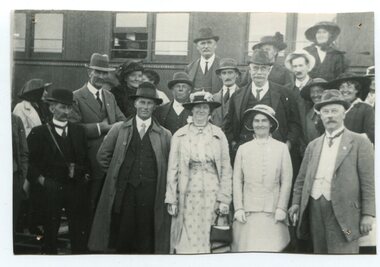
About 1912 work began at Newmerella on clearing the track for the railway line from Bairnsdale to Orbost. A canvas town sprang up on the higher land adjacent to the river flats. Local farmers supplied meat, milk and fresh produce to the camp, as well as gaining employment carting and labouring. The line opened in 1916, the Orbost railway station being built on the Newmerella side of the river. This item is associated with the history of the Orbost-Bairnsdale railway line and therefore reflects the role that the rail line played in the social and economic history of Orbost. On April 10 1916, the first scheduled train service left Orbost for Bairnsdale. The Bairnsdale-Orbost railway was opened to serve the agricultural and timber industry. Because of the decline in traffic and heavy operating costs, the line was finally closed in August, 1987.A black / white photograph of a group of people standing next to a train carriage.orbost-railway east-gippsland-railway celebration-opening-of railway -
 Orbost & District Historical Society
black and white photograph, C1900
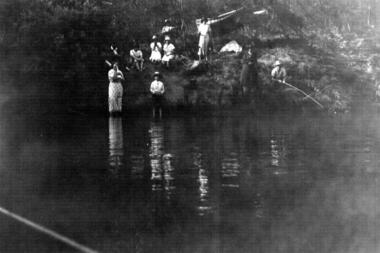
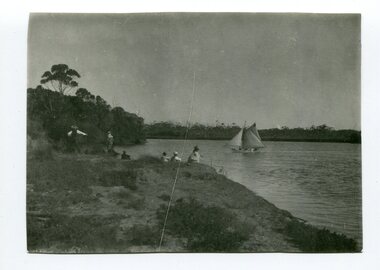
This is a fishing party at Bream Point, Marlo C 1900.Marlo has always been a popular destination for fishing. This is a pictorial record of an early fishing group at Marlo.A black / white photograph of a small group - possibly a family - fishing off a river bank. A small ketch is on the water.on back - Near Bream Pointmarlo-fishing recreation -
 Orbost & District Historical Society
black and white photograph, late 19th century - early 20th century
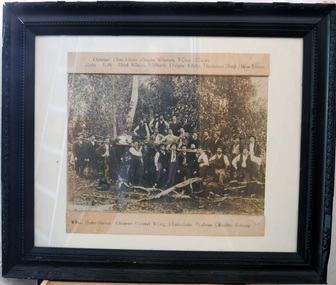
The local logging industry had its beginning back in 1882. The first batch of timber was cut in a sawmill at Orbost on the Brodribb River.Orbost has historically been based on the timber industry, but that industry has declined considerably over the last 20 years. The number of locals involved in the timber industry has declined and many of the mills have closed. This item reflects a time when that industry was a significant contributor to the economy of the district.A very large framed black / white photograph of a large group of timber workers in a bush setting. Above and below the photograph are their names. The names can be clearly read. The photograph is on a white buff card under glass in a black frame.Names are type - written above and below the photograph.timber-industry